You are using an out of date browser. It may not display this or other websites correctly.
You should upgrade or use an alternative browser.
You should upgrade or use an alternative browser.
Computer Navigation Software
- Thread starter chrism
- Start date
-
- Tags
- computer navigation software
Geoff Johnson
Fellow Ericson Owner
See my comments about using a Pocket PC in this thread (a Pocket PC in the hand is worth two laptops in the cabin!). Taking and protecting a laptop on a sailboat seems more trouble than it is worth. I'd rather save my money and if the day comes when I need a sophisticated nav system, I will get one of the networked nav/sonar/radar systems that Raymarine and Garmin are producing.
http://www.ericsonyachts.org/infoexchange/showthread.php?t=146
If you plan to use a laptop, Fugawi has recently come out with an enhanced version of its software that can use the free ENC vector charts produced by our government (http://chartmaker.ncd.noaa.gov/mcd/enc/download.htm). Certainly worth looking into as the charts are by far the biggest cost. Moreover, I understand that the format of those charts is being implemented abroad. If you plan to use a Pocket PC, I think OziExplorer is superior to Fugawi. Maptech also has Pocket PC software, but it seems kinda lame . . . won't run in VGA mode for example.
Last edited:
Geoff Johnson
Fellow Ericson Owner
Let us know what you find out about the ENC charts. I haven't tried them other than to download a chart and get a free viewer from Fugawi. But the viewer obviously doesn't give you a moving chart. One thing that impressed me about them is that you can set the depth contour colors so that everything that is shallower than your keel shows up in a different color. As for Fugawi, $200 software ($100 upgrade, if you already have Fugawi) and free charts . . . can't beat the price.
Last edited:
Nigel Barron
Notorious Iconoclast
I have been using the Nobeltec program for the season, and am pretty impressed by the ease of use and wealth of information. It was pretty invaluable sailing around the San Juans at night this last November.
From what I heard, the charts produced by the government are free, and they are rasterized (zoom in, more detail)
I think I might go with Fugawi... I'm going to look around online.
I got an email from a guy the other day offering me charts of the East and West Coast, Bahamas, Carribean, Med, Gulf of Mexico etc for $350... guess where he got them!?
ONLINE-FREE
I think I might go with Fugawi... I'm going to look around online.
I got an email from a guy the other day offering me charts of the East and West Coast, Bahamas, Carribean, Med, Gulf of Mexico etc for $350... guess where he got them!?
ONLINE-FREE
cost of charts and ENC
I've been using Maptach software and in general I like the functionality that it provides. Others at my work use Nobeltec and are satisfied too. That is not what I want to talk about....
I've talked to Maptech sales reps at the Seattle boat show and come away with the impression that this company is out to squeeze as much money out of the public selling publicly funded chart information for as long as possable. You paid for those charts through your taxes. If you buy a paper chart you can make all the copies you want. But the electronic version cannot be copied so as to protect Maptechs profits er "value added".
I have spoken with some NOAA folks and it appears to me that the chart deal did not go the way that they wanted. I got the distinct impression that they thought that electronic charts should be available for a nominal charge to cover updates and so on. One person went so far as to say that they (and the public) got screwed.
Do a search on BSB format and you will find that there were some law suits where Maptech tried to prevent 3rd parties from making decoders for their encryption scheme (which was a step to protect their chart selling profits). Maptech lost their attempt at monopoly
ENC vector charts are the planned chart format and all US navigation charts are being converted. NOAA says that they are in the public domain to stay. This will force Maptech, Nobeltec and others to support ENC and move their profits to the functionality they provide in their software rather than the reselling of publicly funded charts at excessive prices.
You know (if you hadn't noticed) I am somewhat pissed off at the cost of raster charts. I would be happy to pay for the real cost of those charts. Wait a minute, I did pay for those charts!
Regards, Ethan
Mindscape
Member III
ENC Charts
I just downloaded the ENC charts for Lake Michagan. Nice charts (I used the free Fugawi viewer) but limited in coverage. I understand that charts are being converted - any info on time table? The Lake Michagan coverage is incomplete at this time.
I've been using Blue Charts from a CD for Lake Michagan and have had good luck. But obviously I had to pay for them and use my Garmin stuff to use them.
Geoff Johnson
Fellow Ericson Owner
This is how NOAA justifies the BSB/Maptech raster chart monopoly:
http://chartmaker.ncd.noaa.gov/mcd/enc/me_text.htm
However, the article also indicates that the ENC charts would be handled the same as the raster charts, but that does not seem to be the case.
http://chartmaker.ncd.noaa.gov/mcd/enc/me_text.htm
However, the article also indicates that the ENC charts would be handled the same as the raster charts, but that does not seem to be the case.
gareth harris
Sustaining Member
That article talked about things that 'would happen by 1999' suggesting it is now way out of date - too much work for a GS to keep us informed I guess.
I read an article last year in I think SAIL, this is basically what it said:
NOAA charts were being converted steadily to a vector format, which would be free to download, and some of which is already available. However, the routes frequented by small boat sailors are not their top priority, rather commercial shipping routes that we do our best to avoid, so it may be a while before those charts are the standard for us small timers.
Another thing I read, which sounds like a bigger problem, is that many NOAA charts are less accurate than some of the commercial equivalents. The problem stems from the fact that a $70 GPS is far more accurate than the best navigation system in the world just two decades ago, so there are inherent errors in lat./long. in the compiled charts based on the navigational error in the surveying vessel. These errors do not show up if you are taking sightings on chart features, since they all have the same error, but do show up when you are using a lat./long. from a GPS and placing it on the chart. Couple that with the fact that the basic datum (model of the world to place the coordinates on, which is not an exact spheroid) used in charts of North America was changed 20 years ago from the NAD 27, a drawn up in 1927, to the WGS 84, which tied it into the rest of the world, and as a result was simpler and less accurate, and most importantly, different.
The problem is particularly acute in some areas of the Gulf of Mexico, which were last surveyed by the Royal Navy in the 19th century, who did a truly first class job with what they had, but...
Some commercial chart producers have taken old charts, and done something as simple as drive around the area on a jet ski with a handheld GPS, to produce charts that match GPS coordinates. Nigel Calder talks about finding these charts of the Bahamas the best available.
So how do we deal with this? The effective accuracy of GPS navigation is not as good as the error it reads you on the screen, because the chart was most likely made using slightly different coordinates. A chart plotter may nicely show you in the middle of a deep water channel when you are a couple of hundred yards off. So keeping visual separation from obstacles, and using sight bearings, is still important when it tricky waters. WAAS does not help, as the error is not in the GPS. US Navy warships, although backed by radar, will not go into port in fog using GPS alone. Once you have used a particular chart a few times, you may get a feel for how closely it matches the GPS.
So to go back to the original question, the best systems currently available still seem to be Maptech and Nobeltech, but since this is a very rapidly changing field, the Fugawi may be the best option very soon. I agree with the sentiment that NOAA charts should be available to those who paid for them.
Gareth
Freyja E35 #241 1972
Mike.Gritten
Member III
Aboard Papillon we use the Maptech Offshore Navigator PC charting system and are very pleased with the utility and ease of use of this setup. We "won" the full set of charts for our cruising area in a raffle at last year's boat show ") .
.
I have used and like the "perfect quilting" feature of the Nobeltec products, but I don't like their pricing policies. The Nobeltec products require either a full blown "suite" to be purchased (mucho dinero), or you can buy the piece(s) you want/need at an inflated price (e.g. Tides and Currents). I was already caught in the trap with the "Chartview" products which were acquired by Nobeltec and then scrapped (after pilfering the "perfect quiliting" features). They wanted big money to "upgrade" to their current product. The upgrade price was more expensive than purchasing the full Maptech product, so that's the way we went.
. I have used and like the "perfect quilting" feature of the Nobeltec products, but I don't like their pricing policies. The Nobeltec products require either a full blown "suite" to be purchased (mucho dinero), or you can buy the piece(s) you want/need at an inflated price (e.g. Tides and Currents). I was already caught in the trap with the "Chartview" products which were acquired by Nobeltec and then scrapped (after pilfering the "perfect quiliting" features). They wanted big money to "upgrade" to their current product. The upgrade price was more expensive than purchasing the full Maptech product, so that's the way we went.
Chart errors
All kidding aside, I can vouch for charting errors many would consider significant. I serve as navigator on many offshore sailboat races, and have observed these differences in the Gulf's of Mexico and California, Carribbean, the Great Lakes and the west coast of Mexico. In several cases they were large enough to give serious pause-I don't recall anything that would have put us on the bricks, but it was evident we were not where we expected to be. Being from the "old school", I am perhaps more sensitive to these kinds of differences, but for sure, when you plot your GPS-derived lat/lon on your NOAA chart, see if you can verify the same location using another means (Loran would be an interesting comparison, and triangulation (if close enough for good readings).
Fair winds,
S
mark reed
Member III
C-map charts
I've been using C-map cartridges in a JRC radar/chartplotter for the past 2 seasons. I like this system because I can see the screen from the helm. In over 1500 miles of coastal cruising, I've only seen one significant C-map charting error. The chartplotter showed me to be slightly outside of the winding (and fortunately well-buoyed) channel into Walter's Cove (Kyuquot). The error was the same on several return trips in and out of the cove.
I initially bought Nobeltec VNS 6.x, but realized that I could neither fit nor afford a screen that would allow viewing from the helm. I really like the Nobeltec software but now use it only for route planning.
Mark Reed
SV Southern Cross
e38-200 #250
Portland, OR
Geoff Johnson
Fellow Ericson Owner
Here are screen shots of the Block Island, RI (Great Salt Pond) chart at 40% and 10% on a VGA Pocket PC using OziExplorerCE:
Attachments
-
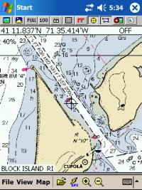 VidyaScreen002.jpg239.8 KB · Views: 215
 -
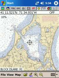 VidyaScreen003.jpg267 KB · Views: 219
Geoff Johnson
Fellow Ericson Owner
No, I had purchased the Maptech Region 3 charts in 2002, so I just used them. That's about the size of my known sailing world right now (although I am going cruising in Turkey in May and have found an appropriate (and maybe even accurate) chart on the Internet for $4). You can get free raster charts from Maptech from its Outdoor Navigator website (https://outdoornavigator.maptech.com/outdoornavigator/index.cfm) but it appears they will work only with its $20 Pocket PC software (which does not yet support VGA). You might try contacting the developers at OziExplorer and Fugawi to see if they will support those charts. (The OziExplorer developer apparently wrote the software for his own use is supposed to be very responsive to requests. He also must be a very gifted programer.) In addition, the Fugawi software (which I don't think is as good as the OziExplorer - not as many levels of zoom for example) will convert the ENC vector charts into raster charts for use on a Pocket PC.
Confused yet?
Confused yet?
Last edited: