Magellan CrossoverGPS as Chartplotter?

JohnK

Member II
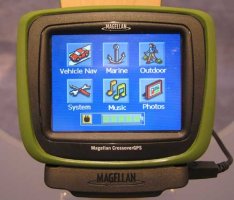
For Xmas, I bought my wife a Magellan CrossoverGPS for her car. It's pretty good for street navigation and was on sale for a great price. It's "crossover" in the sense that it can be used for outdoor and marine navigation being waterproof and somewhat ruggedized. The marine capability comes from accepting extra cost SD cards with "easy to use BlueNav™ marine charts based on highly respected Navionics Gold charts". Does anyone know what's up with these charts and whether this contraption would work for, say, Southern New England coastal navigation?
 

Attachments

  • ces_magellan_crossover3.jpg
    ces_magellan_crossover3.jpg
    24.5 KB · Views: 46

Rob Hessenius

Inactive Member
BlueNav

John- Sure, this unit will work for you with the properly selected region that you want. I dont believe that it will interact with other pieces of equipment i.e autopilot, DSC VHF, misc.

Regards,
Rob Hessenius
 

exoduse35

Sustaining Member
bought it for my wife for Christmas.....will it work on MY boat???? no wonder our wives want jewelry! thanks a lot my wife's birthday is coming up, wonder if she would like that new drill Ive been eyeing?
 

Emerald

Moderator
yeah, I just read this post out loud to my wife, and got a "he bought it for his wife? yeah, right!"

Remember, you can't flinch when she goes for a car ride the same time you go out on the boat, and reaches for the GPS before you do!

Go for that drill, and I'll let you know how my wife likes the autopilot....:devil:
 
Last edited:

exoduse35

Sustaining Member
I think if I go for the drill my wife will test it somewhere below the belt! Or worse yet,the water line!!!!!!!!!!!!!!!!!!!!!!!!!!!!!!!!!!!!!!!!!!!!!!!!!!!!!!!!!!!!!!!!!!:scared:
 
Top