Almost like radar!

paul culver

Member III
It was time to upgrade to a DSC VHF radio and I ended up with a Standard Horizon Matrix GX2100. This unit has an integrated AIS receiver which displays position, course and speed of AIS transmitting ships relative to your boat. Just fired it up and it works nicely. You can also select a target from the display and call them up directly through the DSC feature, and ask them something like "do you see me on your radar?". Its about $400, a lot less than the competing products from Garmin etc. Plus its loaded with other features such as loud hailer and fog signals if you want to make some noise.
 

Rocinante33

Contributing Partner
I've been keeping my eye on those, too. Let us know how well it works, how is the display, etc.

I think the prices are coming down.
 

paul culver

Member III
Hi Keith

A long overdue update on the AIS function in this new radio:

It works great as a "radar" for commercial shipping, and I was surprised to see signals from a lot of private yachts as well. One thing I found to be a bit annoying is getting a collision warning as I approached harbors, presumably from docked vessels failing to turn off their AIS transmitters. I disabled the alarm in these cases.

Paul
E29 "Bear"
 

Maine Sail

Member III
As one who sails in the NE AIS is a nice addition but AIS is no panacea or a replacement for radar, at least not yet.

Roughly 95% of the boats we encounter along the Maine coast are NOT displaying AIS and neither are we with the Matrix 2100 so we are more part of the problem rather than solution at this point.

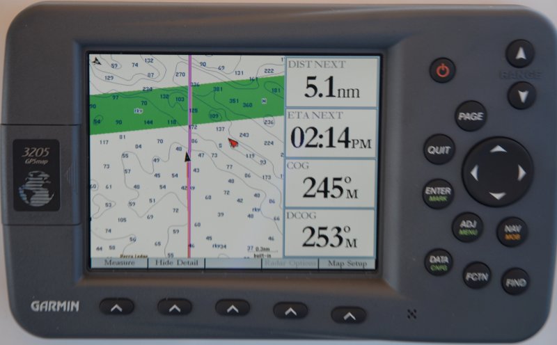
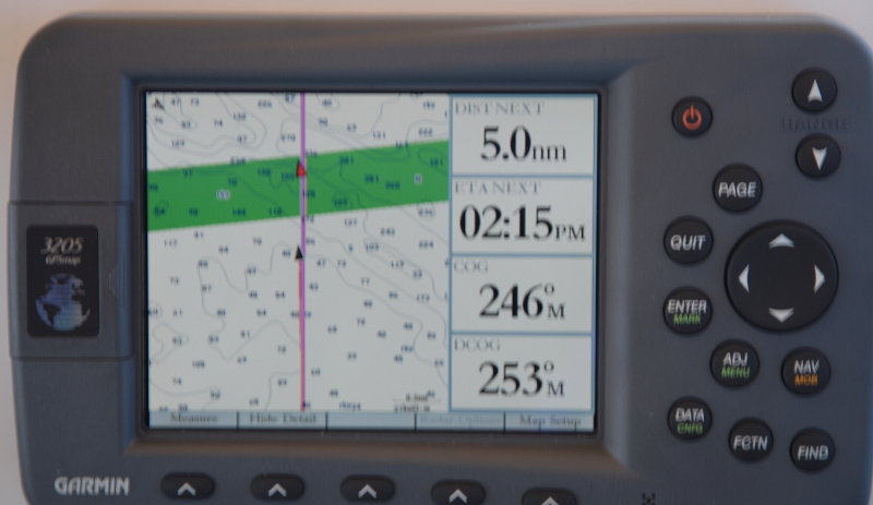
When we do get a vessel on AIS the system can be very SLOW to update the TXing ships ACTUAL location. I have actually taken photos of my screen, see below, showing the vessel off my quarter stern when the vessel TXing is now actually off my bow and already passed me. In real fog this is an UNSAFE feel good device that could potentially cause real harm if not used in conjunction with radar as a supplement or very carefully tracked. In order to make the most efficient use of the bandwidth available, vessels that are anchored or moving slowly transmit less frequently than those that are moving faster or are maneuvering. The AIS refresh rate can range from as long as 3 minutes to as fast as 2 seconds for fast moving vessels. The big problem is that not all boats are supplying SOG/STW info and you can be guessing at the refresh rate.

AIS needs to be used with respect if using them in an area that gets fog and with the understanding that at this point only some commercial ships and a small handful of pleasure vessels use and TX AIS.

These photos should give you an idea of how inaccurate, compared to radar, AIS can be. We were doing 6 - 6.2 under sail and that boat was moving slightly faster than us but not TXing SOG. Look at my position on the chart at .3 nm range compared to the AIS vessel in red. If this was in fog, and your only device for collision avoidance was AIS, this could be very dangerous if you had not been tracking it for a while or they made a sudden course change. This was in bright sun so no danger. I moved less than .1 of a nautical mile when the AIS boat went from photo position #1 to position #2 in a split second refresh rate. Not cool if in pea soup..

Sorry for the blurry photo.

128208300.jpg


128208304.jpg
 
Last edited:

Rocinante33

Contributing Partner
Thanks Paul & MS,

If I get AIS it will be used in conjunction with my old, but still highly functional, radar in fog. OTOH,when I am crossing that shipping channel in broad daylight at a sedate 6 knots, it sure would be nice to call up to the bridge of that monster that is still 2-3 nm away, but its bearing (with respect to my view of them) is not changing. My radar is almost always off when visibility is good.
 

stuartm80127

Member II
Ais gx2100

I have a Standard Horizon CPS-180 chartplotter to which I connected the Sitex AIS engine. Worked reasonably well this past summer.

One learned issue with AIS is that the Navy doesn't always transmit on AIS or if they do, I am convinced it's spoofed to hide their actual position. We saw some pretty funky AIS ship names out in the Pacific Missile range and they were frequently changing positions by 20-30nm faster than a ship should travel. While 50nm wnw of San Diego, we came within 1/2 mile of an Aegis Cruiser doing approx 30kts at 0130 and my AIS showed absolutely nothing. When it started doing helecopter excercises it displayed a bogus name for an hour until it sped off back into electronic darkness. Boy those ships can turn/stop on a dime.

AIS allowed me to safely navigaste the newly imposed shipping lane mess off the coast of CA as I went from Santa Cruz to Catalina and down to San Diego. Boy what a mess that was. I liked the old lanes better but hey, I don't live in S. Ca anymore:). At 0330 on a dark low cloud deck night, AIS accurately informed me that freighters now also come up along the southwest side of Catalina to get into LA. Still nothing better than using ones own ears and eyes though.

Has anyone connected the GX2100 to a Std Horizon CP180 chartplotter and get accurate graphical results? Doing so for the Sitex unit was quite a hack job but it works.

Stuart
 
Top