• Untitled Document

    Join us on April 26th, 7pm EST

    for the CBEC Virtual Meeting

    All EYO members and followers are welcome to join the fun and get to know the guest speaker!

    See the link below for login credentials and join us!

    April Meeting Info

    (dismiss this notice by hitting 'X', upper right)

GPS / Chart options

mggilmore

Member II
I want to replace my ancient GPS soon. What I would really love is a setup that let's me combine GPS functionality with Charts, and to take that one step further I would love if I could integrate (or load) the charts on my laptop too so that I could sit at home and plan trips, etc. Any recommendations? Oh yeah, one other thing, I would prefer not to spend a small fortune on it :egrin:
Thanks
Mike
 

PDX

Member III
Avoiding spending a small fortune is going to mean getting a smallish screen. The value leader IMO has been the Standard Horizon CP-300. It has full chartplotter functionality as well as the ability to add in AIS, depth, and radar. The screen is 5 x 7" I believe. Street price as of about a year ago was in the $600 range for the GPS/chartplotter unit by itself including antenna.
 

bknight365

Member I
Opencpn

I want to replace my ancient GPS soon. What I would really love is a setup that let's me combine GPS functionality with Charts, and to take that one step further I would love if I could integrate (or load) the charts on my laptop too so that I could sit at home and plan trips, etc. Any recommendations? Oh yeah, one other thing, I would prefer not to spend a small fortune on it :egrin:
Thanks
Mike

Take a look at opencpn. I just started testing it out on my laptop. For a navstation or home route plotting it seems to be a decent package. I believe you can integrate AIS / radar / most NMEA. You can use the free download US gov. charts.

http://opencpn.org/

ben
 

mherrcat

Contributing Partner
I just started playing with OpenCPN when I saw it mentioned in another thread.

Kind of fun to plot out routes and see ETAs based on different speeds, etc.

Since I have no experience with any on-board chart plotters I was wondering if the vector charts I am seeing really have so little detail compared to the raster charts. I was looking at the same area on both versions and based on what I saw I would say give me the raster charts any day.
 

TRMN8R

Member II
Just downloaded OpenCPN last week, went to NOAA for local electronic (ENC) and raster (RNC) charts, downloaded them, ordered and received the GlobalSat BU-353 USB GPS puck, and for about $30 bucks total have a BACKUP chartplotter to use...................support is excellent by way of the Cruisers Forum on which they have an active section of threads. Have fun!
 

mherrcat

Contributing Partner
I downloaded the NOAA charts, too.

Are the vector charts really that limited in detail when you zoom in or am I doing something wrong? I'm pretty sure I downloaded all the charts for the west coast.
 

steven

Sustaining Member
I use OpenCPN (release 2.3.1) and it is very good. Note however that all bearings are True. If you navigate Magnetic to match you compass heading, then you have to convert external to the program.


--Steve
 

rwthomas1

Sustaining Partner
My biggest problem with using a laptop for navigation is that its a laptop! A spilled cup of coffee can render it useless, not to mention a good dose of saltwater. For backup, sure, why not. But for primary nothing beats a dedicated chartplotter. Even better if it does radar too. I can dump bucket after bucket of seawater on my Furuno and it keeps working. And likely, thats what will be happening when you need it most. If I was choosing a new CP I would go with a Furuno Navnet 3D. Not cheap, but digital radar and all the charts are INCLUDED! Charts are free, vector or raster will work, or you can purchase Jep or Nav if you want them. My understanding is that you can load any chart format and it will work.

Understand that I boat in a sometimes congested area, tight quarters with commercial traffic in pea soup, can't-see-the-bow, New England fog. Messing about with a laptop in that stuff? No thanks. RT
 

Stu Jackson

C34IA Secretary
Another option is SeaClear. For about $30 you can get the CD with all the free charts instead of downloading them, the SeaClear program and a hockey puck GPS dongle USB.
 

steven

Sustaining Member
openCPN update

an update on OpenCPN: there is a plugin available that calculates magnetic declination so you can correct. Not a big deal unless you voyage far, since you can look it up at NOAH and it usually doesn't change much if you stay close to home. Approx. -11 deg for Chesapeake. Of course you still have to do the arithmetic to sail the compass heading. (e.g., Magnetic compass course is True software course minus 11deg).
 

Rocinante33

Contributing Partner
Has anybody tried the Std Horizon CP 300 chart plotter/GPS? It seems that it might be a reasonably priced, multifunction unit. 7" screen & one it can add displays of fishfinder/sounder, radar, AIS. I see it for about $600-650. I think it can be mounted at the helm and removed for storage, IIRC. It comes in versions with either an internal GPS antenna or an external for a few $$ more.

http://www.standardhorizon.com/inde...28DBFB4198E3A2773B4&DivisionID=3&isArchived=0
 

PDX

Member III
Has anybody tried the Std Horizon CP 300 chart plotter/GPS? It seems that it might be a reasonably priced, multifunction unit. 7" screen & one it can add displays of fishfinder/sounder, radar, AIS. I see it for about $600-650. I think it can be mounted at the helm and removed for storage, IIRC. It comes in versions with either an internal GPS antenna or an external for a few $$ more.

http://www.standardhorizon.com/inde...28DBFB4198E3A2773B4&DivisionID=3&isArchived=0

No, I am in the process of refitting my boat and have not yet installed the CP 300. I have purchased one and have been assembling some peripheral add in units piecemeal. I can tell you that the chartplotter, depth-fishfinder black box, depth transducer, AIS (Milltech), and radar (Si-Tex small unit) will run you about $2000-2500 total, depending on how hard you look for bargains. And that obviously doesn't include a radar platform. Eliminating the radar will cut that in half.

Internet feedback on the small Standard Horizon units, CP300 and CP180, has been quite good.
 

Rocinante33

Contributing Partner
PDX,

Thanks for the comments. I already have the AIS in the Std Horizon combo VHF/AIS. The AIS is just not yet functional as the old GPS cannot interface with it. I may upgrade the radar at a later date (or not?). I have an old Raytheon radar unit already and an equally old Garmin GPS & plotter. They share the same old clunky monochrome CRT display. I need to upgrade the GPS/CP so I can get the AIS functionality and I would like to upgrade the radar to get rid of the old CRT display, but that will come later. First the GPS/CP. The fishfinder/sounder can be another incremental step in building a whole system....but not all at once.

Are you mounting your CP 300 at the helm or inside at the nav station? Did you get the internal GPS/antenna or the external. I am considering mounting at the helm and removing the unit for storage. If so, I think I would get the internal GPS. I am also considering a Lowrance unit, but the SH seems like more for the $.

Please let us know how you like it when it is operational.
 

PDX

Member III
Are you mounting your CP 300 at the helm or inside at the nav station? Did you get the internal GPS/antenna or the external. I am considering mounting at the helm and removing the unit for storage. If so, I think I would get the internal GPS. I am also considering a Lowrance unit, but the SH seems like more for the $.

Please let us know how you like it when it is operational.

Neither. My boat has a tiller--hence doesn't really have a helm. The tillerman will stand in the forward half of the cockpit. I am flush mounting the unit to the companionway bulkhead.

If I recall correctly, Standard Horizon recommends the external antenna if the unit is mounted inside the cabin and internal if you are using it in the cockpit. Mine is kind of in between so I'm not taking any chances. I got the external antenna. Its not that much more money.
 

aquavit

Member II
I installed the CP180i on my boat and I really like it. I have had no problems getting a compromise between chart detail and area coverage that works well for my sailing speeds. You can purchase a planner adapter that allows you to use your charts on your PC and download routes etc. to the GPS. I have also installed an Actisense DST unit that digitizes the output from my depth/temp transducer and sends it by NMEA 0183 to the CP180i. It could also show speed if I had a transducer for that in the hull. There is still a small glitch with the Actisense data but my installation is probably at fault and Actisense support has been great. I also have the GPS connected to my VHF for DSC purposes. I would recommend this GPS unit based on performance and price.

Glenn (Aquavit)
 

Rocinante33

Contributing Partner
I installed the CP180i on my boat and I really like it. I have had no problems getting a compromise between chart detail and area coverage that works well for my sailing speeds.

Glenn (Aquavit)

Glenn,

Where did you install yours? Below decks?
 

aquavit

Member II
Keith;

I mounted it on the binnacle guard. I found a great little bracket at my favourite chandlery. The bracket snaps onto the 1" tube of the guard and I mounted the supplied Standard Horizon bracket on top of that. I ran the wire through the guard tube and under the cockpit floor where I installed a junction box for all of the wiring connections. I could provide a photo for you but it will have to wait until at least the weekend.

Glenn
 

aquavit

Member II
Keith;

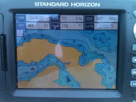
I finally remembered to take a photo of the mount for my CP 180. I also took one of the screen showing the gauge inputs on the chart screen. Good luck with your installation.

cp1801.jpgmount.jpg

Glenn
 
Top