Advice re: SF Bar / Golden Gate / Offsore near San Francsisco

N.A.

E34 / SF Bay
Hello folks-

In another thread @Pete the Cat made some extremely helpful comments that I would like to have in a separate thread for ease of those searching for such information later (don;t want sailing advice buried in an anchor rode discussion.) Hence I am reposting his comments here, with some additional links.

--> Additional advice re: sailing out the Golden Gate, and roughly in the area from Half Moon Bay to Drake's Bay and out to the Farallones, would be appreciated.

Thanks!

Pete the Cat's comments (emphasis added):
from thread https://ericsonyachts.org/ie/threads/e34-anchor-well-how-much-rode.21255/

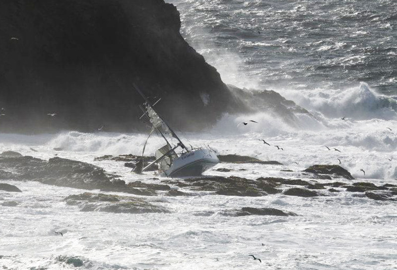
As you have noted, the Pacific Coast is mostly a lee shore with few harbors of refuge. My most dangerous near misses in my cruising life have not been having an anchor too small, but rather having too little personal fortitude to pick up and get out when things start to get dicey in lee shore situations before I had no choice but to stay on a boat that was pitching too violently to even inspect and manage chafe, much less pick up the gear. I was lucky each time, but in retrospect, it was not wise or seamanlike. I worry that so much marketing has gone into "never drag" anchor brands and types that folks are going to be lulled into the easy, but very dangerous choice to hunker down behind a $1000 anchor, when the only safe thing to do is get out in deeper water. And do it sooner rather than later.

I have sailed extensively outside the Gate and remind folks that you should never go South until you are beyond the first Channel marker buoy in any weather -- you cannot always see the NW breaking swell before you are in it going South. Coming North you should come close to the lightship buoy (outside the separation zone and watch for the big guys out there moving at 20+Kts) before turning right into the Gate. The folks who end up on Ocean Beach are under reported -- I had one very near catastrophe many years ago when I cut things too close to coming North -- the swell is deceptive and the top current will take you ashore faster than you can motor or sail, even if the waves are not yet breaking. The only thing that saved me was luck. Had I been another mile or two offshore, I would have had no problem.

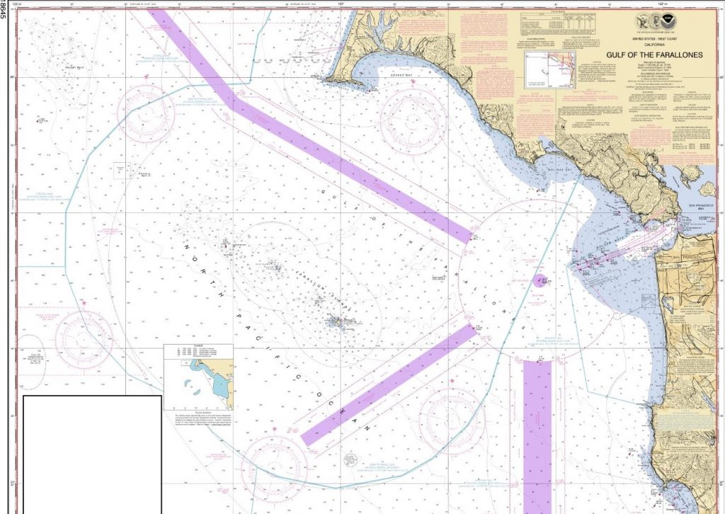
I (N.A.) am adding some links for those going outside the Golden Gate. I think most folks know to avoid the Potato Patch and South Bar, and not to go out on an ebb if there is much swell/wind, but these go into additional detail (and the entire point of this thread is that sometimes yet more detail -- like the critical 'top current' off Ocean Beach -- shows up in discussions of 'avoid the South Bar' that seem like they are already known.

Links for others digging on this:
Really good page on SF / Golden Gate Bar: https://coastsidefishingclub.com/grey-beard-articles/the-san-francisco-bar/
Very good thread (esp. comments by George Benson (George B) "Gulf of the Farallones-Golden Gate Primer": https://www.sailnet.com/threads/san-francisco-bay-bar-and-currents.243729/#post-3358993
 

N.A.

E34 / SF Bay
@Pete the Cat

I think I worded my post badly, as a number of folks have viewed, but no posts with advice. Since I still have hopes for more advice re: sailing offshore in the SF vicinity, if you're willing, I am curious about a couple of things in your original post:

- “Never go South until you are beyond the first Channel marker buoy in any weather -- you cannot always see the NW breaking swell before you are in it going South.”
--> Am I right that you mean "turn after getting out past G1/R2" / the outer end of the main ship channel? I ask only because the 1st buoy coming out would be R8, which seems close in to turn.

- “Coming North you should come close to the lightship before turning right into the Gate.”
--> Why go farther out (lightship buoy) before turning into the Gate, whereas it's OK to turn South closer in (at the outer end of the main ship channel)? I would have thought if anything that the “you cannot always see the NW breaking swell before you are in it going South” would imply it's better to go farther out (lightship buoy) before turning South.

Lastly,
--> Can you say more about the “top current” – is that a general thing off many beaches, or specific to Ocean Beach for some reason? I have never heard of it and it seems pretty important to understand.

Any other advice on the thread topic (from any of you) also appreciated.
 

Loren Beach

O34 - Portland, OR
Senior Moderator
Blogs Author
I have only a few trips in or out of the Golden Gate, and those were crewing other boats. Each time the skipper stayed in the channel quite a ways out. i.e. not cutting any corners.
Interestingly, this is also the best & safest advice for entering the Columbia River over its notorious bar, which I have done on a variety of boats including my own.
 

Pete the Cat

Member III
I have only a few trips in or out of the Golden Gate, and those were crewing other boats. Each time the skipper stayed in the channel quite a ways out. i.e. not cutting any corners.
Interestingly, this is also the best & safest advice for entering the Columbia River over its notorious bar, which I have done on a variety of boats including my own.
@Pete the Cat

I think I worded my post badly, as a number of folks have viewed, but no posts with advice. Since I still have hopes for more advice re: sailing offshore in the SF vicinity, if you're willing, I am curious about a couple of things in your original post:

- “Never go South until you are beyond the first Channel marker buoy in any weather -- you cannot always see the NW breaking swell before you are in it going South.”
--> Am I right that you mean "turn after getting out past G1/R2" / the outer end of the main ship channel? I ask only because the 1st buoy coming out would be R8, which seems close in to turn.

- “Coming North you should come close to the lightship before turning right into the Gate.”
--> Why go farther out (lightship buoy) before turning into the Gate, whereas it's OK to turn South closer in (at the outer end of the main ship channel)? I would have thought if anything that the “you cannot always see the NW breaking swell before you are in it going South” would imply it's better to go farther out (lightship buoy) before turning South.

Lastly,
--> Can you say more about the “top current” – is that a general thing off many beaches, or specific to Ocean Beach for some reason? I have never heard of it and it seems pretty important to understand.

Any other advice on the thread topic (from any of you) also appreciated.
I think folks know that the top layers of a large wave go a bit faster than the lower levels. As you get closer to shore, and the wave is building up because bottom is coming up rapidly, the top layer (I am sure there is a diagram of this somewhere on the net) will gather relative speed until it spills over when the wave actually breaks. I have heard this referred to as the top current. It can help a boat surf going downwind with the swell--your SOG will seem inordinate, but it is real. But I have been going South with a sizable swell off my quarter (prevailing wind along the coast is NW or WNW) and not realized I am coming to a place where the waves are actually breaking before going ashore. The breaking waves are hard to see from the backside. As I mentioned, once you are inside of those breaking waves on Ocean Beach you will need some power to get back behind them and that could be beyond your sail and engine power--I almost bought it once. I once witnessed a boat rounding the South Farallon during a race and he cut a bit close inside a swell that was breaking occasionally on the island. The next wave caught him and he missed being crashed on the rocks by a few yards. A couple years later, a racing boat got caught in a wave in the very same place and went ashore on that Island with a loss of life and the boat. I do not approve of these islands being used as racing marks for this reason, I have expressed this to the race committees decades ago, but I believe they still are doing it. I am not going to suggest a standard about how far one should be off these areas because it will vary with the recent offshore storms (some of them very far away), but any time there is the possibility of breaking waves (generally because the ocean is suddenly more shallow against a large swell) it is a good thing to be further offshore. Swells carry a lot of energy and near shore deserve respect.
I think the rest of the Northern California Coast is a lee shore , but does not have hidden dangers like Farallons and Ocean Beach. But the entrances to Half Moon Bay, Santa Cruz and Morro Bay can be dangerous-- I think the CG monitors Morro Bay and issues warnings at Santa Cruz, but I would avoid all of them with breaking waves near the approaches. You can go to the second buoy South of Half Moon Bay (if you can see flat water beyond the breakers) when there are breaking waves at Pillar point, but I am not recommending it for the novice.
Folks probably know this, but there is a general knot or so of current from N to S along the Northern California coast to Point Conception. This makes coming back up a slog, and sometimes and adds to the wave configurations if the wind is S or SW. It is possible to find back eddies near shore. If you can find a Brian Fagan book on the California Coast (yes he wrote one on the Channel Islands as well) he has it nailed and I recommend it--an old copy is just fine--timeless information if you are doing coastal cruising. I am less of a fan of listening to folks like me talking at the dock or on Active Captain. Fagan spent decades out there and writes succinctly from experience.
 

G Kiba

Sustaining Member
A wake-up call for many Bay Area sailors.
 

Loren Beach

O34 - Portland, OR
Senior Moderator
Blogs Author

Grim Trivia-- the article references several deaths in 1982, and I was acquainted with one Portland couple that perished when their small sailboat was broken apart. i.e. only a few pieces of the boat were ever found. The crew was not found.
 

Pete the Cat

Member III

Grim Trivia-- the article references several deaths in 1982, and I was acquainted with one Portland couple that perished when their small sailboat was broken apart. i.e. only a few pieces of the boat were ever found. The crew was not found.
While surf groundings are not a regular occurrence, there is no place I know where there is cumulative data recorded. The Farallon race loss caught the attention because of the number of lives lost, and that it was extensively reported by a sailing magazine, Latitude 38, and because a lot of other sailors were in that race or have raced that course. There have been numerous groundings in the surf off Northern California (particularly Ocean Beach) where the boat is lost and yet the crew manages to escape. These sometimes just get a paragraph buried in some publication if they are reported at all.
My experience of narrowly escaping a surf grounding on Ocean Beach 40 years ago left me terrified of the prospect. I recall the feeling off Pt. Conception one night going North; the wind was only 18kts or so and the swell seemed high 15'-18' but the period seemed long so I left Coho at about 2am because things were not going to get better in the next few days. When I got out there, the swell started to get a bit higher (I don't know how high it was night, just higher-- maybe 20?) and the wind picked up to 25 kts--it was not supposed to do that. I realized I was making 2kts or less SOG at one point (motoring) and an hour later the swells started to break. I really did not want to turn around (though that might have been the safer option). Luckily, the wind started to moderate in a few hours and the swell moderated with it. I stumbled into Morro Bay the next evening and fell asleep instantly for 14 hours after I picked up a mooring. I have had luck when my judgement failed.
 

N.A.

E34 / SF Bay
Thanks, folks!

- I appreciate the pointer to Fagan's cruising guide! In these internet-enabled days I tend to forget to check the print sources. I picked up a copy and it seems very good. Many thanks for the suggestion.

Re: the purpose of this thread, Fagan says (p. 85), "Most coasting yachts approach the Golden Gate from the N or S, using either the Bonita or South Channel." The book then has a full page on using the South channel... which, in fairness, discusses not using it when any swell is present. Still,

--> My understanding is that the more general view boils down to "there is no South Channel; get that out of your head."

Pete the Cat's earlier comments seem to support this "stay away from Ocean Beach" view, and he's in good company:

E.g., from the Coastal Fishing Club link in my first post,
"On the charts there is an area marked called the “South Channel”. This area has claimed many boats and many lives due to the fact that there is no discernable channel here. Also, many boats run out to the east side of the channel then run south to avoid the traffic in the ship channel, and they end up crossing the south bar on its outside edge. This area is very dangerous since in contains “first generation breakers” that seem to pop out of no where since it the first spot the wave hits the bar. This is what happened to the former bass player from the band “Loverboy” a couple of years ago. They never did find his body or the steering wheel of his boat that he was hanging on to when the breaker hit. This is just one boat of many that has met its fate here."

and from the SailNet link in my first post,

"Look along the coast off Ocean Beach (the SF side). That's the South Channel. I think that place is a death trap. On a calm day it looks so simple. Go out the Gate and turn left. On a falling tide, if there is any swell you can sail into a shallow spot and the door in front, behind and outside closes into shallow water with breaking waves. I've done that channel a few times when the surf is really small, but I've given up on it, it's just not worth the chance to me anymore."
Followed by agreement in a post from George Benson,
"I’m with you. There is something about sailing in the same patch of water where the USCG does their surf rescue training that doesn’t appeal to me."
Note that George himself wrote a (print; now e-book) cruising guide to the North Coast FYI, so he is no random internet poster.

Which brings me back to the point of this post -- local knowledge! Sometimes it is informative above and beyond very good Guides. If you've got that inside knowledge, add it to the thread :)


PS: Farallones/"Low Speed Chase" -- there is, not surprisingly, a lot out there on that. I don't want this thread to be just about the LSC tragedy, but three links discussing the Farallones that may be of general interest (some of which also discuss LSC) are:
Sailnet link from above
"... be aware there can be a North to South current running upwards of 1 knot at SE Farallone in typical NW conditions."
 

Pete the Cat

Member III
There are several buoys near the Farallons that would make better racing marks than tempting some inexperienced person (my first view of the Farallons was in a race 45 years ago) to cut that corner and end up on the beach--I would have crossed too close had I not seen the guy in front of me almost get grounded by a breaking swell. I hope the sponsors are at least briefing racers these days. Those notes seem to suggest they are not.
While one of my Maine neighbors was the creator of Active Captain, I still prefer having a paper cruising guide to study when they are written by disciplined folks who spent more than a night or two in a particular place. I still keep paper charts for planning purposes--maybe it is just the old Luddite in me, but perspective and options seem more difficult on screens you need to manipulate. Charlies Charts of the West Coast and the Mexican Coast to Panama are useful publications as well as the Brian Fagan books. The marina and services data is, of course, out of date, but graphic approaches general sailing directions seem to be missing from Active Captain contributions. I don't think Jeff Siegel (who developed Active Captain) ever thought folks would give up cruising guides for his program.
 
Top